

Multiple tornadoes were reported across Florida this morning as Hurricane Milton made landfall in the Sunshine State. However, these are not ordinary tornadoes; they develop in a unique way.
Traffic camera footage circulating on social media captured one tornado traveling through Fort Pierce, situated on Florida’s east coast. The tornado was seen lifting a substantial amount of debris into the air as it advanced.
Another tornado that was spotted at the Spanish Lakes Country Club north of Port St. Lucie along Florida’s Atlantic coast reportedly caused severe damage. “It looked like someone had dropped a weight from the sky and flattened a bunch of houses,” resident of Lakewood Park in St. Lucie County Doug Anderson told Treasure Coast Newspapers.
“One of the last houses I went to looked like it had been ripped in half,” he said. “The people were out front crying.”
The National Weather Service (NWS) issued a flurry of tornado warnings as the historic storm impacted the coast. Unlike the familiar twisters of the central U.S, these tornadoes develop through a completely different process, according to experts.
“If the driving rain and wind isn’t enough to convince you to remain sheltered in place, there is also the very real threat of tornadoes, even in the outer bands of #Milton,” the NWS posted on X, formerly Twitter.
“These tornadoes spin up quickly and move even more so—making staying in a safe place the best possible option.”
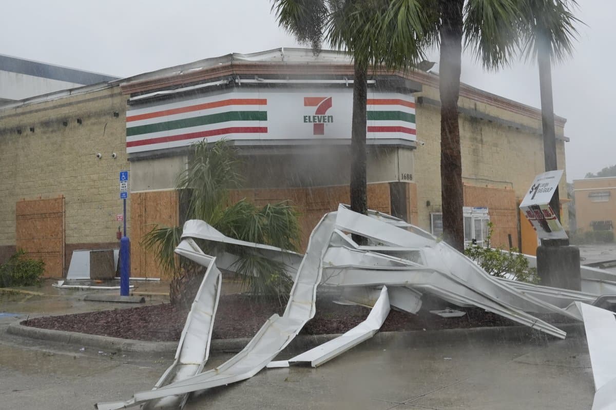
An apparent tornado caused by Hurricane Milton, tore the awning off a 7-Eleven convenient store, Wednesday, Oct. 9, 2024, in Cape Coral, Florida. While usually weaker and more short-lived than traditional tornadoes, these spin-up tornadoes can still cause severe damage.
Marta Lavandier/AP Photo
Known as “spin-up tornadoes” or “gustnadoes,” these intense vortexes develop when powerful downdrafts of rain-cooled air from thunderstorms generate strong winds at the leading edge of a storm, referred to as the “gust front.”
When wind speeds reach significant levels, friction at the surface can disrupt the airflow, leading to the formation of a rotating vortex at the gust front. This vortex originates at ground level and can extend hundreds of feet into the air, resulting in a spin-up tornado.
Despite their name, spin-up tornadoes are distinct from traditional tornadoes. Actual tornadoes arise when warm updrafts of air feed into a supercell thunderstorm cloud, connecting to its base, with rotation driven by the cloud itself. In contrast, spin-up tornadoes do not connect to the cloud base and originate from the cool downdrafts ahead of the storm.
If the driving rain and wind isn’t enough to convince you to remain sheltered in place, there is also the very real threat of tornadoes, even in the outer bands of #Milton. These tornadoes spin up quickly and move even more so – making staying in a safe place the best possible… https://t.co/437hrZM5wy
— National Weather Service (@NWS) October 9, 2024
“Gustnadoes, sometimes referred to as spin-up tornadoes, are distinct from tornadoes,” Suzanne Gray, professor of meteorology at the University of Reading, U.K, told Newsweek.
“The National Oceanic and Atmospheric Administration does not identify them as tornadoes but instead thunderstorm wind events. These ‘spin-up’ tornadoes don’t come from supercells. Instead, they develop along boundaries, such as the gust fronts that form due to downdrafts in severe thunderstorms. They don’t connect with any cloud base rotation and so are different to tornadoes.”
Discussing the gustnadoes that formed from Hurricane Helene two weeks prior, Jennifer Collins, a hurricane researcher and professor of geosciences at the University of South Florida, previously told Newsweek, “With no specific warning often for these spin-up tornadoes, they pose a great risk as they pop up, and you could easily get wind gusts of over 90 mph, which can cause damage, destruction, and loss of life.”
Despite warnings issued by the NWS, these gustnadoes are notoriously difficult to forecast.
“Spin-up tornadoes are very difficult to detect on radar with their smaller size, and they do not have a classic severe weather signature from a supercell storm as it is a non-supercell tornado found within a line of storms,” Collins said.
“So because they spin up quickly, it is often difficult to get specific tornado warnings out, but often there could already be severe thunderstorm warnings in place, and we know hurricanes often spawn tornadoes.
“As quick as they can spin up, they are short-lived and relatively weaker than a super-cell tornado and can dissipate just as quickly.”
Do you have a tip on a science story that Newsweek should be covering? Do you have a question about tornadoes? Let us know via science@newsweek.com.


